
COBRA CBD GPR
SKU COBRA CBD GPR
Original price
£0.00
-
Original price
£0.00
Original price
£0.00
£0.00
-
£0.00
Current price
£0.00
Shipping
1-3 days delivery
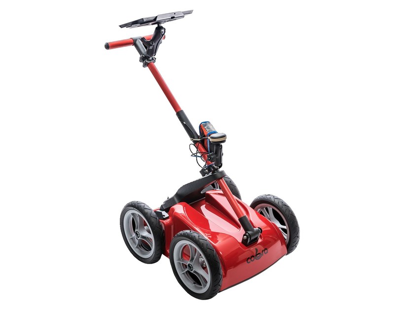
COBRA CBD GPR
The Cobra CBD GPR uses a patent pending unique triple frequency antenna design (200, 400 and 800 MHz nominal frequencies).
Because the CBD antennas emit three ultra-wideband pulses (150% of nominal frequencies compared to 100% for conventional antennas), which overlap and merge, it can replace several antennas with nominal frequencies between 200 and 800 MHz.
Areas of use:
- Gather information about conditions below the ground surface
- When laying different types of lines, it is important to know what the ground conditions look like, such as depth and if there are mountains, as well as if there are existing lines or cables to facilitate, for example, excavation work, which can otherwise be very costly.
- The data is saved in CAD file or Google Earth
- See the thickness of an asphalt road or to find wires under the asphalt
- Can be used on concrete to locate reinforcing bars, steel beams, voids, cracks, pipes and castings
- Can locate bedrock or the water table
- See the thickness of an ice sheet and what's underneath
- Can also be used in archeology where you search for old objects, such as remains or graves
- Can be compared to an echo sounder. The only difference is that the ground radar operates above ground and the sonar under water
- Cost-effective solution
Technical specification
| ANTENNA / GPR 2 channel Ground Penetrating Radar system with shielded antennas | |
| Antenna type | CBD* Multi Frequency Antenna (* Patent pending) |
| Nominal frequencies | 200/400/800 MHz |
| Operating bandwidth | 50-1400 MHz |
| Applied voltage | 200 V |
| Sample rate | 100,000 samples/second |
| Scan rate | 1-100 scans/s per channel @ 512 samples/scan |
| Sample output | 16 bit digital raw data |
| CONTROL UNIT / CU Selectable PC/PDA, Rugged, MIL-STD-81F/G, water- and dust resistant, IP-65 or IP-67 with bundled data acquisition. DAQ software for control, display, processing and storage of GPR data | |
| Data format | Standard Geophysical SEGY Data Format (.sgy) |
| Data channels | 1 or 2 with individual settings for depth, filter and gain |
| Vertical filters | Off, Digital |
| Horizontal filters | Stacking, Background removal |
| Gain points | 1- 10 Linear gain |
| Gain levels | 0 to +60 dB |
| Data storage | Raw data storage with memory for Gain used |
| Data file size | Limited only by available HDD space |
| SURVEY CART Push and Pull non-metallic handle and support, tactical RAM-mount, cradle for recommended and purchased rugged PDA/PC. 12" quick release non-inflatable wheels. High resolution SW encoder | |
| ENVIRONMENTAL | |
| Temperature | -20°C to 40°C internal temperature |
| Humidity | 96% non-condensing |
| Ingress protection | IP68 connectors |
| MECHANICAL | |
| Size (L x W x H) | 60 x 52 x 29 cm |
| Weight | 15 kg |
| OPERATING | |
| Operating platforms | Airborne operation, high speed air-coupled operation, ground-coupled operation |
| Battery | Integrated 73 Wh Li-Ion |
| Operating time | 8 hours |
| Operating mode | Manual (1-100 scans/s), Distance (SW encoder) with or without GPS |
| GPS positions | GPS positions integrated with GPR data for every scan in both time- and distance mode |
| Operating depth | 0-2000 ns selectable. Typical 0-500 ns. Depth range 0 - 10 m depending on ground properties |
| ACCESSORIES | |
| Hardware | Helicopter survey kit, Road/Railway kit, Transport case, High accuracy GPS, Harness |
| Software | GPR Data Acquisition software included (COBRA DAQ) for Cobra Wireless GPR and Cobra Plug-In GPR. PRISM Post processing software with 3d export module (Voxler, Reflex 3d, GPRSlice) |
